

G.Lilley-Moncrief has used ArcGIS Explorer Online to create an excellent case study of flooding in the UK. Whilst it focuses mainly on the floods of 2012, there are some others there too. It will work best if opened into a bigger browser window using the link uner the map..
View Larger Map


Tuesday 19 November 2013
Sunday 27 October 2013
UK Storms October 2013 - Collaboration Project
Labels:
Case Study,
Projects,
wallwisher
Below is an opportunity to collaborate on a case study project for any Bedford School Geographer, or indeed anyone else there. Just Click a space on the wall and post your most interesting information about the UK storms. We challenge you to be the most interesting. Mr Gracie will provide some edible German confectionery to the most interesting post.
We think this format may have the power to do some quite special collaborative work too, so please do contribute if you find anything interesting... You can click on the wall below to post or open it in a new window with this link: http://padlet.com/wall/BSStorm
We think this format may have the power to do some quite special collaborative work too, so please do contribute if you find anything interesting... You can click on the wall below to post or open it in a new window with this link: http://padlet.com/wall/BSStorm
Pictures From the Iceland Trip
The box below can be accessed more effectively using the fullscreen button in the top left of the Iframe.
Wednesday 23 October 2013
Follow the Iceland Fieldtrip
You Can Follow the Iceland Fieldtrip at the link below:
http://www.bsgeogiceland2013.blogspot.co.uk/
They are having a great time, so keep an eye on it regularly.
http://www.bsgeogiceland2013.blogspot.co.uk/
They are having a great time, so keep an eye on it regularly.
Saturday 5 October 2013
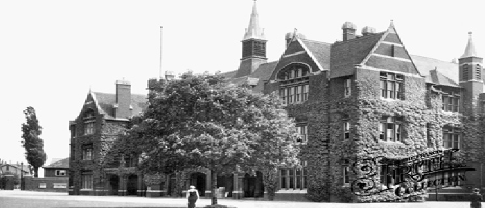
Open Day Guerilla Investigation
Labels:
guerrilla geography,
Investigations,
mapping
Hypothesis:
There will be more pedestrian activity closest to the main school building.
Method:
Synchronised 5 min pedestrian count at 9.40am at varying distances from school.
Pragmatically sampled at locations known to be on the tour path.
Graphical Evidence of what location looks like.
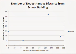
Results:
Scatter Graph of Pedestrians vs Distance
Interactive Map of Results (click on Green Pins for Results)
View Larger Map
Analysis
There is no clear correlation of results. The centre of school was only the second highest result. However, being near the car park means we could remove the top result as an anomaly. It is more than twice the size of the next largest result. If this was removed, the centre of school would be the highest result, but from a set of 3 points.
Therefore, we cannot support our hypothesis with this data. If we include the car park result, then we can actually disprove it.
Evaluation
We only took a 5 minute period early on the Open day, at only 4 locations. This did not allow us an even spread of the school site and removes the temporal factor that may see pockets of people ebb and flow at sites during a day.
There will be more pedestrian activity closest to the main school building.
Method:
Synchronised 5 min pedestrian count at 9.40am at varying distances from school.
Pragmatically sampled at locations known to be on the tour path.
Graphical Evidence of what location looks like.
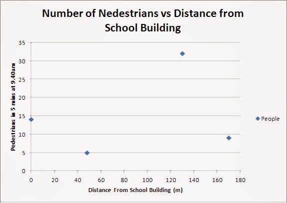
Results:
Scatter Graph of Pedestrians vs Distance
Interactive Map of Results (click on Green Pins for Results)
View Larger Map
Analysis
There is no clear correlation of results. The centre of school was only the second highest result. However, being near the car park means we could remove the top result as an anomaly. It is more than twice the size of the next largest result. If this was removed, the centre of school would be the highest result, but from a set of 3 points.
Therefore, we cannot support our hypothesis with this data. If we include the car park result, then we can actually disprove it.
Evaluation
We only took a 5 minute period early on the Open day, at only 4 locations. This did not allow us an even spread of the school site and removes the temporal factor that may see pockets of people ebb and flow at sites during a day.
Thursday 3 October 2013
Quality Y10 Tectonics Vids
Mr Strachan's Y10 class have been making videos about plate tectonics. See the examples below:
Could you do the same?
R.Sanghera
Toby
Could you do the same?
R.Sanghera
Toby
Wednesday 25 September 2013
Pakistan Earthquake
Labels:
A Level,
Case Study,
earth hazards,
earthquakes,
GCSE,
storify,
tectonics
Below is a storify of various sources showing the causes, effects and responses to the earthquake in Pakisatn on tuesday the 24th of September:
Wednesday 4 September 2013

Thursday 18 July 2013
Useful Weather and Climate Videos
Labels:
A Level,
AS,
ClimateChange,
Climatic Hazards,
Video
Below are some excellent videos from the Met Office which explain some important basics of weather and climate patterns:
How does the Earth's Climate System work?
What is the Jet Stream?
What are Weather Fronts?
What are Air Masses?
How does the Earth's Climate System work?
What is the Jet Stream?
What are Weather Fronts?
What are Air Masses?
UK Heatwave - Causes, Effects and Responses
Labels:
A Level,
Case Study,
Climatic Hazards,
competition,
UK,
Video
We are in the midst of a heatwave and though its the school holidays, it makes for a great case study for A2...
You can see a Q and A transcript from the BBC weather team here.
Try the BBC Heatwave Quiz here. (Can you beat Mr Gracie who got 5/7?)

Wednesday 17th saw temperatures rise up to 32.2 degrees in places which moved the UK up to a level 3 warning. Ths video gives an overview of this weather.

What are the Causes of it?
The Causes and why warnings are issued are explained HERE. It is a result of a blocking anticyclone
This video explains how long it may last and why
What makes a heatwave?
What are the effects of it?
Numbers of grass fires have increased - The London fire brigade have been tackling 21 grass fires a day compared to 5 a day last year.
Ambulance Callouts are up too
Its predicted to have claimed up to 760 lives
Negative effects may be enhanced by us being ill prepared as explained here.
Positively - the hot weather increases natural sugar levels in grapes improving the 2013 UK wine vintage
Some holiday parks have reported bookings have much improved - so the UK tourist industry has received a boost.
This outdoor pool in Leicestershire for example has seen numbers swell.
How have we responded?
There are national warnings as mentioned above, mostly given by the Met Office. An example of the NHS health warnings
There are lots of public health warnings going out to givwe advice on how to respond
This video explains who is most at risk and how to respond
Various media outlets have also given their own advice such as this BBC one.
You can see a Q and A transcript from the BBC weather team here.
Try the BBC Heatwave Quiz here. (Can you beat Mr Gracie who got 5/7?)
Wednesday 17th saw temperatures rise up to 32.2 degrees in places which moved the UK up to a level 3 warning. Ths video gives an overview of this weather.
What are the Causes of it?
The Causes and why warnings are issued are explained HERE. It is a result of a blocking anticyclone
This video explains how long it may last and why
What makes a heatwave?
What are the effects of it?
Numbers of grass fires have increased - The London fire brigade have been tackling 21 grass fires a day compared to 5 a day last year.
Ambulance Callouts are up too
Its predicted to have claimed up to 760 lives
Negative effects may be enhanced by us being ill prepared as explained here.
Positively - the hot weather increases natural sugar levels in grapes improving the 2013 UK wine vintage
Some holiday parks have reported bookings have much improved - so the UK tourist industry has received a boost.
This outdoor pool in Leicestershire for example has seen numbers swell.
How have we responded?
There are national warnings as mentioned above, mostly given by the Met Office. An example of the NHS health warnings
There are lots of public health warnings going out to givwe advice on how to respond
This video explains who is most at risk and how to respond
Various media outlets have also given their own advice such as this BBC one.
Monday 10 June 2013
What Influence the effects of earthquakes?
Labels:
A Level,
Development,
earth hazards,
earthquakes,
GIS,
tectonics
The map below shows major earthquakes (magnitude in red circles) and their effects (blue squares = no of deaths). Investigate what they show using the mouse to click symbols for further info then try to work out why they differ so greatly.
View Larger Map
View Larger Map
Wednesday 29 May 2013
Fox hunting adaptation
Labels:
AS,
coldenvironments,
Snow,
Video
Animals and plants must adapt to survive in cold environments. Long periods of freezing temperatures and precipitation falling as snow mean that both food and water are scarce. Animals can adapt in both physical and behavioural ways. One of the best surely must be the way that the fox below hunts mice:
To see further clips of animal adaptations to the yellowstone winter, see the BBC clips site for the episode here.
To see further clips of animal adaptations to the yellowstone winter, see the BBC clips site for the episode here.
Wednesday 22 May 2013
Nintendo: A Global Company
Labels:
4th Form,
Best Work,
Case Study,
Globalisation,
Prezi,
yr 9
A. Arshad has produced an excellent review of Nintendo's operation as a global company which is below. It demonstrates well placed examples at times and is an example of how to make a presentation visually interesting:
Tuesday 21 May 2013
Oklahoma Tornadoes
Labels:
A Level,
Case Study,
Climatic Hazards,
news,
storify,
Tornado
There has been a huge tornado in Oklahoma, part of a series of large twisters this month. Though relative to a tropical storm the area covered is more narrow, the damage from the hazard of strong winds is very severe with winds thought to have reached 200mph. At least 2 people died and 21 were injured on Sunday. The storm has been classified as EF-4 on the enhanced fujita scale. You can see how tornadoes form and 2 storify versions of the event below:
Thursday 16 May 2013
Cyclone Mahasen - A Case Study
Labels:
A Level,
Bangladesh,
Case Study,
Climatic Hazards,
Tornado,
Tropical Storm
Cyclone Mahasen is beginning to make landfall in the Bay of Bengal today...
A useful study for A level students is below:
Causes
A quick reminder of Hurricane formation is here. The shallow coastal shelf and warm seas in the Bay of bengal will channel Cyclones and magnify their strength as they approach land.
The path of the storm and its storm surge can be seen below:

Hazards
Tropical storms bring the fourfold hazard of strong winds, heavy rain, storm surges and large waves.As it goes these are not as severe as they could be since it satarted to make landfall at low tide and the winds have only been clocked at 60mph thus far. It has been reported as not being severe in twerms of these primary hazards but Bangladesh's low lying and flat terrain still make it susceptible to the secondary hazard of flooding from storm surges and the heavy rain may induce a secondary hazard - landslides.
Effects
Thus far, 2 people have been reported dead in Bangladesh and up to 50 Rohingya muslims being evacuated may have drowned as an evacuation boat capsized.
Dozens of houses collapsed in Patuakhali district as it inundated the land with waist deep water.
Though ti did not make landfall in Sri lanka, the heavy rain triggered mudslides and floods which killed 7 people.
Responses
Bangladeshi authorities have given out a warning level of 7 out of 10 for the incoming storm in the low lying areas around Chittagong and Cox's bazaar; a good example of identifying areas most at risk and focussing strategies to mitigate for hazard risk.
The main response has been the evacuation of large numbers of people from areas at risk. At least 956,372 people have been evacuated in Bangladesh to more than 3200 storm shelters. All schools and colleges and some hotels have been declared cyclone shelters. In Burma more than 160,00 people have been evacuated.
Bangladesh has also shut airports in the areas at risk.
Magnifying the Hazard
The presence of tens of thousands of Rohingya Muslims displaced by internal conflict last year in temporary refugee camps in Rakhine state has increased the overall risk from this storm.
Scale
In terms of the strength of the primary hazards it is not as large as it could be, but the scale in terms of area covered is still large - affecting 3 countries and millions of people. By contrast the Tornadoes in Granby in Texas (link here) have kileld at least 6 as a result of much more forceful wind but have affected a much smaller area of land, thus decreasing the overall risk of the hazard.
A link to the BBC news story on the event is HERE
A useful study for A level students is below:
Causes
A quick reminder of Hurricane formation is here. The shallow coastal shelf and warm seas in the Bay of bengal will channel Cyclones and magnify their strength as they approach land.
The path of the storm and its storm surge can be seen below:
Hazards
Tropical storms bring the fourfold hazard of strong winds, heavy rain, storm surges and large waves.As it goes these are not as severe as they could be since it satarted to make landfall at low tide and the winds have only been clocked at 60mph thus far. It has been reported as not being severe in twerms of these primary hazards but Bangladesh's low lying and flat terrain still make it susceptible to the secondary hazard of flooding from storm surges and the heavy rain may induce a secondary hazard - landslides.
Effects
Thus far, 2 people have been reported dead in Bangladesh and up to 50 Rohingya muslims being evacuated may have drowned as an evacuation boat capsized.
Dozens of houses collapsed in Patuakhali district as it inundated the land with waist deep water.
Though ti did not make landfall in Sri lanka, the heavy rain triggered mudslides and floods which killed 7 people.
Responses
Bangladeshi authorities have given out a warning level of 7 out of 10 for the incoming storm in the low lying areas around Chittagong and Cox's bazaar; a good example of identifying areas most at risk and focussing strategies to mitigate for hazard risk.
The main response has been the evacuation of large numbers of people from areas at risk. At least 956,372 people have been evacuated in Bangladesh to more than 3200 storm shelters. All schools and colleges and some hotels have been declared cyclone shelters. In Burma more than 160,00 people have been evacuated.
Bangladesh has also shut airports in the areas at risk.
Magnifying the Hazard
The presence of tens of thousands of Rohingya Muslims displaced by internal conflict last year in temporary refugee camps in Rakhine state has increased the overall risk from this storm.
Scale
In terms of the strength of the primary hazards it is not as large as it could be, but the scale in terms of area covered is still large - affecting 3 countries and millions of people. By contrast the Tornadoes in Granby in Texas (link here) have kileld at least 6 as a result of much more forceful wind but have affected a much smaller area of land, thus decreasing the overall risk of the hazard.
A link to the BBC news story on the event is HERE
Thursday 2 May 2013
#bsgeogdebate : The Outcome
"This house believes that global warming is one of the fundamental problems humanity must deal with".
The event was oversubscribed, but whether standing, sitting or lingering in the doorway, those present were given a treat. The proposition focussed on the extent of scientific support and evidence and the potentially far reaching consequences, whilst the opposition replied questioning the motives of scientific evidence the convolution of myriad sources in determining its causes and the elaboration of effects by the proposition. It finished with an attack on Al Gore delivered flamboyantly by J.Strode, which though humorous and scathing was tempered and ultimately defeated by P.Ziya's calm presentation of returning to the key science and potential outcomes. The #prostrode lobby would add of course that the opposition did win the audience vote, though the motion was carried by the judges.
You can listen to the debate again Here. Many thanks to Aquilla Radio for recording it and hosting it in their player. (Currently track 9 on the player)
A tense crowd awaits the debate...
Monday 22 April 2013
The Big Geography Debate
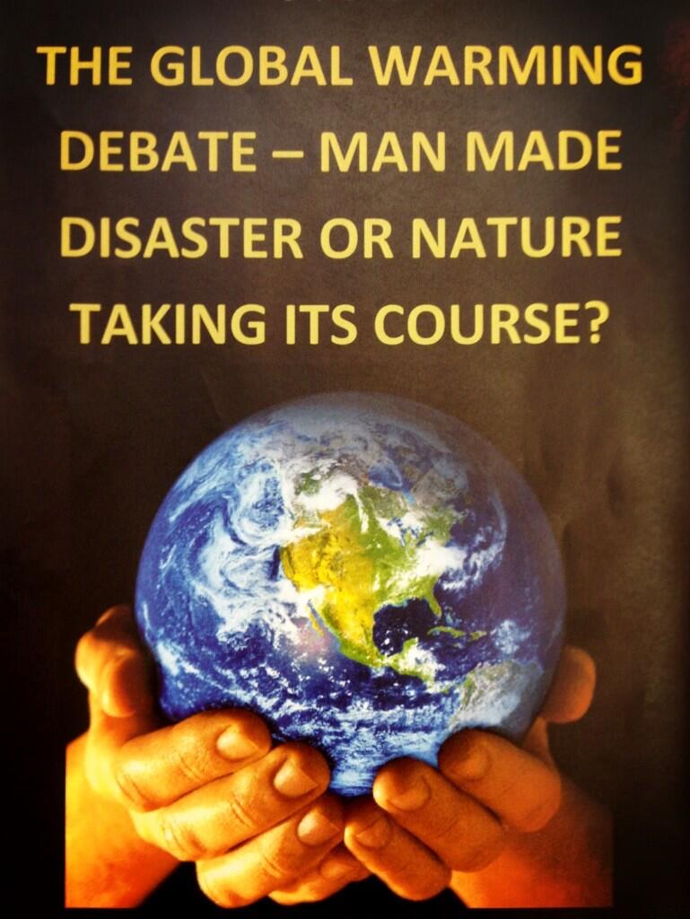
The time is finally upon us... This Friday sees the inaugural Bedford School Geography debate in A21 at 1pm. It is on a topic that we frequently find ourselves discussing in lessons and one which the Upper sixth think they can bring to a satisfactory conclusion. The motion for the event is:
Be there to support it and bring testing questions. J.Stroomer and J.Strode will be taking the lead on the two 3 man teams and are particularly partisan supporters of either side with Strode being an avowed climate sceptic and in strong disagreement with his arch climate change nemesis Stroomer.
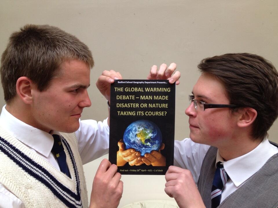
"This house believes that global warming is one of the fundamental problems humanity must deal with"
Be there to support it and bring testing questions. J.Stroomer and J.Strode will be taking the lead on the two 3 man teams and are particularly partisan supporters of either side with Strode being an avowed climate sceptic and in strong disagreement with his arch climate change nemesis Stroomer.
Tuesday 16 April 2013
Proper Geography Revision...
Labels:
Case Study,
IB,
revision
J.Herbert has set standards high with his revision strategy for IB Geography below:
The start of term is an ideal time to share your revision ideas. Tweet them using #bsrevision. Lets share ideas and create a positive twitter revising phenomenon!!!

The start of term is an ideal time to share your revision ideas. Tweet them using #bsrevision. Lets share ideas and create a positive twitter revising phenomenon!!!
Wednesday 27 March 2013
UK Snow - an OCR A2 Case Study example
Labels:
A Level,
Case Study,
Climatic Hazards,
Depression,
Snow,
UK
The recent bad weather can make an excellent case study for the climatic hazards section of the OCR A2 Global issues Paper:
The syllabus looks for:
"The study of high and low pressure systems and air masses to illustrate the formation of hazards, ie heavy snowfall and frost, and how they represent hazards to people through blizzards and cold spells. They then look for the impacts associated with these weather features for named areas at the local, regional and global scale, including impacts on:
– transport;
– agriculture and forestry;
– health;
– economic activity. "
So lets take a look...
Videos:
A number of issues looked at around the Isle of Arran, W.Scotland
Causes:
The Jetstream has fixed in a position south of the UK drawing in colder air masses from the North. Explanation Here. A blocking anticyclone is sitting to the North of the UK which is drawing in predominantly North Easterly air masses due to its clockwise rotation. This has brought the cold and its blocking nature is the reason why the original cold weather has become a Cold Spell.Video The reason it snowed a lot at first was down to warm moist air from our regular prevailing South Westerly winds meeting cold air masses. This forced the warmer air to rise but also cool and condense. The extreme cold means that it fell as snow rather than rain. ie Heavy Snowfall. This has very much been a national scale hazard with most parts of the UK experiencing both heavy snow and the cold spell. The scale is caused by the movement of the jetstream which draws weather down from the North for the whole of the UK and also affected parts of Western Europe. The area covered by the anticyclone is large but the winds rotating around it can easily cover an area the size of the UK.
Impacts:
Transport:
A school group from Calder High school in Arran were trapped at a fieldtrip centre in Yorkshire since driving conditions became too treacherous.
Extreme rural areas have been cut off for a number of days in the Peak District, Cumbria and Wales. Link.
In South West Scotland, drivers on the A75 in Dumfries and Galloway were trapped overnight in their cars.
Road, rail, ferries and flights were all disrupted in Northern Ireland.
All flights at Humberside airport were briefly stopped.
Agriculture:
The conditions came in at lambing season threatening the lives of sheep stuck in drifts and therefore nthe livelihoods of pastoral farmers. This has especially been true in rural parts of Northern Ireland and Scotland.
http://www.bbc.co.uk/news/uk-21936592
http://www.bbc.co.uk/news/uk-21936873
Health
A small number of people were killed as a result of exposure by getting trapped in poor conditions int he snow. Some of these were as a result of taking part in riskier activities such as hillwalking in the Scottish Highlands.
One example can be seen here
Economic Activity
Many sporting fixtures were lost which bring revenue in at both a local and regionals cale depending on their significance. The transport disruption meant many people lost working days.
The first section of this paper will also look for
Management
Regional Scale
http://www.bbc.co.uk/news/uk-21921896
Teams of engineers have been dispatched to areas of Arran without power. This has taken longer in rural communities. This could be appropriate because of Government assistance in emergency funding and the UK having a well trained workforce in this area.
National Scale
http://www.bbc.co.uk/news/uk-northern-ireland-21917589
Multiple agencies in Northern Ireland have coordinated rescue efforts together. This is possible due to mixtures of public and private funding. High levels of training and effective communication and transport infrastructure.
At a smaller scale, farmers on the Isle of man have coordinated at the community level to assist in rescuing liovestock and to find extra shelter and food from other farmers and locals for them.
http://www.bbc.co.uk/news/uk-21945465
In the UK, a number of key agencies transmit important safety information widely via the internet and social media sites such as twitter. the include the BBC, the Met Office, The Environment Agency and National Rail. This allows people to maximise the time they have to prepare for a hazard or plan their personal responses to it, such as travel routes.
Specially trained rescue teams resued drivers stuck on roads. Link
Links
http://www.bbc.co.uk/news/uk-21907837
Monday 18 March 2013
(The Only) Solution to Desertification?
Labels:
Arid Environments,
AS,
ClimateChange,
Climatic Hazards,
Development,
Sustainability,
Video
The issue of desertification is one of the prime issues of our present and our future. Alan Savory gives an excellent TED Talk below analysing what he sees as the only viable solution.
Questions to Consider:
How big an issue is Desertification?
Could there be other solutions?
Is it too late to solve this problem?
Questions to Consider:
How big an issue is Desertification?
Could there be other solutions?
Is it too late to solve this problem?
Evaluation of Coastal Management at Swanage
J.Hutchings (Y9) has written an evaluation of coastal management at Swanage. Click on the image to enlarge it, then read the evaluation underneath.
Do you agree with his assesment of the current strategies?
Would you manage it differently?
Would you manage it at all?
(Comment Below or tweet @bsgeography)

Do you agree with his assesment of the current strategies?
Would you manage it differently?
Would you manage it at all?
(Comment Below or tweet @bsgeography)

Evaluation
Judging by the fact that the officials in charge of the area (described on annotated map) have a main focus of ensuring a sustainable future for the coastal area of Swanage, I think that there is little to be done regarding changes. It is said that plans dealing with the future of the coast are currently being reviewed, processed and produced, but in the meantime they are continuing to allow the defences already set up to prevent erosion getting out of hand.
Regarding the defences themselves, however, I think that a different approach would have been more adequate. Having a long system of groynes stretching across some of the coast is good, as it helps to stabilise the beach and keep it in one piece. The sea walls do their job, but it doesn’t quite meet the needs of a sustainable balance. They are particularly expensive (one of the most expensive coastal defence concepts) and are also unappealing to the public. While it may meet the needs of the environment, it fails to do the same socially and economically.
There are no ideal options when it comes to social sustainability, as even though there may be more suitable solutions in terms of appearance, none contribute significantly enough to make it worthwhile. However, perhaps a series of rip-raps or gabions could have been used, as these are less expensive than sea walls and still manage to absorb the waves’ energy relatively successfully.
Lost Continent Discovered
Labels:
4th Form,
Case Study,
Coasts,
tectonics,
yr 9
· 21st February 2013: Scientists have discovered huge pieces of a continent from millions of years ago in the Indian Ocean.
According to the “National Geoscience”: scientists from England, South Africa, Norway and Germany have discovered land which is at the bottom of the Indian Ocean and has a width of 25- 30 km from 50-80 million years ago from a continent called Rodinia.
Scientists think that thisland was removed as a result of volcanic explosions which broke the land off from the main continent. Then gigantic waves caused by earth quakes sent the island to the bottom of the Indian Ocean. Scientists named this piece “Mauritia”.
Scientists say that the continents today are all detached from Rodinia and made today’s world in the last 1 billion years.

It is 2 thousand km away from Africa’s southeast, in the 115 islands of the Seychelles and the island of Maritius. While scientists were investigating the sand pieces there, they discovered that the pieces belonged to a volcanic explosion which had happened 9 million years ago.
According to the Norwegian scientists, the pieces of the sand which they took the sample from Seychelles include Zirconium. They thought the Zirconium in the sand came from another piece which had met the bottom of the Indian Ocean as a result of the volcano and the waves.
With sonar and seismic submarines, it has been proved that there was this land with a width of 25- 30 km under the Indian Ocean.
By N. Aslanoba (y9)

Wednesday 27 February 2013
Cyclone Rusty: Case Study
Labels:
Australia,
Case Study,
Climatic Hazards,
Cyclone,
Video
Cyclone Rusty is hitting the North west Coast of Australia today.

You can follow the storm's progress live here.
It started out as a tropical storm in the pacific last weekend (video) and has become more organised into a tropical cyclone, potentially category 4.
It was upgraded to a category four storm early on Wednesday, one notch short of the top category.
600mm of rain is being forecast in a 24 hour period. Given that the UK averages somewhere around the 900mm mark per year, that is a significant amount.
Early video as the storm approached:
BBC Video of the storm's predicted path
The Australian Bureau of Meteorology has predicted the storm's likely path and has issued warnings for the various hazards that it may bring. See them HERE
You can See BBC Video of residents preparing as storm makes its initial landfall HERE
The Pilbara region, close to where Rusty has hit, is the world's largest source of Iron Ore. Residents in the area have also prepared to be locked indoors for a few days as they prepare for the storm to pass over. Video
The slow movement of the storm is a concern as it may amplify the flooding and storm surge hazards it will bring. Web Article The residents should be fairly well prepared since the area has experienced gale-force winds from 49 cyclones, seven of which caused destructive gusts in excess of 170 km/h [106 mph]. Cyclone Joan produced the strongest gusts ever recorded at Port Hedland -208 km/h [130 mph] in 1975.
The most destructive tropical cyclone to strike the area since Joan in 1975 was George, which delivered wind gusts estimated to have reached around 200 km/h [125 mph] in March 2007. In the Port Hedland area most residential and commercial structures performed well, and structural damage was sustained by fewer than 2 percent of buildings, most of which proved to have weaknesses due to poor maintenance.
The West.co.au reports:
You can follow the storm's progress live here.
It started out as a tropical storm in the pacific last weekend (video) and has become more organised into a tropical cyclone, potentially category 4.
It was upgraded to a category four storm early on Wednesday, one notch short of the top category.
At its centre, it had intensified to a strength of 230km/h (143mph), with satellite data indicating the eye of the storm was 20 nautical miles wide, Australian media reported.
600mm of rain is being forecast in a 24 hour period. Given that the UK averages somewhere around the 900mm mark per year, that is a significant amount.
Some of Rusty's other terrifying statistics
- Winds of at least 230km/h
- Cloud temperatures colder than -52C surrounding the eye of the storm
- Recorded rainfall of over 138 millimetres per hour near Rusty's western side
- Thunderstorms in Rusty's eye reported to have reaching heights of over 12km (7 miles)
Early video as the storm approached:
BBC Video of the storm's predicted path
The Australian Bureau of Meteorology has predicted the storm's likely path and has issued warnings for the various hazards that it may bring. See them HERE
You can See BBC Video of residents preparing as storm makes its initial landfall HERE
The slow movement of the storm is a concern as it may amplify the flooding and storm surge hazards it will bring. Web Article The residents should be fairly well prepared since the area has experienced gale-force winds from 49 cyclones, seven of which caused destructive gusts in excess of 170 km/h [106 mph]. Cyclone Joan produced the strongest gusts ever recorded at Port Hedland -208 km/h [130 mph] in 1975.
The most destructive tropical cyclone to strike the area since Joan in 1975 was George, which delivered wind gusts estimated to have reached around 200 km/h [125 mph] in March 2007. In the Port Hedland area most residential and commercial structures performed well, and structural damage was sustained by fewer than 2 percent of buildings, most of which proved to have weaknesses due to poor maintenance.
The West.co.au reports:
The Department of Fire and Emergency Services warned there was a possible threat to lives and homes in Marble Bar, Nullagine and De Grey Station because of rising rivers and streams.
Residents near the Yule and Turner river catchments near Port Hedland were also preparing for flooding.
Residents near the Yule and Turner river catchments near Port Hedland were also preparing for flooding.
The bureau’s Neil Bennett said a 3.5m to 4m storm surge was predicted, which could increase to 10m if Rusty crossed at high tide at midday.
“But it’s likely to cross later in the day, so it’s going to be bad but not the worst it could be,” he said.
“This is a nasty system.
“It’s going to lead to issues with flooding, roads being cut, structural damage, power lines are likely to be down and add that to the water everywhere and that’s going to be a dangerous environment for people to be moving around in.”
Mr Daccache said a 4m surge would inundate the town’s west end. “We’ve got pumps ready to flush the water out as quickly as we can,” he said.
Thursday 14 February 2013
UK Floods - an avoidable hazard?
Labels:
A Level,
AS,
Case Study,
Climatic Hazards,
flooding,
rivers,
wallwisher
Have a scan through the Wallwisher discussion below. Matching planning and investment to the potential costs of flood events is a tricky business. What is your opinion, were the floods avoidable?
If nothing else, the video links are worth a follow up:
If nothing else, the video links are worth a follow up:
Wednesday 13 February 2013
UK Cold Weather - Causes and Effects
Labels:
A Level,
Best Work,
Climatic Hazards
Year 13 pupils did an overnight investigation into why we have had such cold weather in January. A summary by T.Walker of the causes and some useful effects are included below.
(Click the image to enlarge)

Thursday 7 February 2013
Santa Cruz Aftershocks
Labels:
Case Study,
earth hazards,
earthquakes,
GIS,
Remove Form
Large earthquakes will often be followed by many aftershocks. The one near the Solomon Islands yesterday has had a number. The map below illustrates it excellently:

A number of the aftershocks have been greater than 5 on the richter scale.
A couple of questions that might guide your thinking:
Why might aftershocks still cause much damage though they are smaller than the original earthquake? Can people prepare for aftershocks?
Click on the map above to go to its live site hosted by the USGS, or click below to see another aftershock map of the area from earthquaketrack.com HERE.
Wednesday 6 February 2013
Monday 4 February 2013
Durban Climate Summit - Discuss...
Labels:
ClimateChange,
Development
C.Krueger has collated some statements about the Durban climate summit below. What do you think? Are these effective in helping to alter climate change? Should we be worried about climate change at all?
Respond with opinions below this post or tweet @bsgeography
Respond with opinions below this post or tweet @bsgeography
The Durban
Climate Summit
"Climate change is the
greatest emerging humanitarian challenge of our times, causing suffering to
hundreds of millions of people worldwide," – Kofi Annan, former UN secretary-general
and president of the Geneva-based Global Humanitarian Forum (GHF)
“The latest science is telling
us we are in more trouble than we thought.” –Janos Pasztor, UN climate
adviser
The annual ritual of discussions
to restrict global warming to within 2 degrees was performed at Durban from
November 28 to December 9 2011. Thousands of experts, government negotiators,
campaigners, and businessmen gathered and talked, talked, talked… There was
considerable skepticism if ever the “dirty boys” of the planet would learn to
behave responsibly.
What is the
basic issue?
The temperature on the Earth is rising due
to global warming, and it is rising at a speed which scientists attribute to human
actions leading to excessive emission of CO2 and other greenhouse gases that
trap heat. This has changed, and is changing the weather patterns everywhere. The
prediction is that a global temperature rise beyond 2 degrees Celsius can lead to
catastrophic climatic disasters beyond control.
Evidence of
Global Warming?
The statistics from the International
Disaster Database found out that in the last 5 years of the 21st
century, there were more global disasters recorded than in during the last 200
years. In the period of time between 1900 and 1910 for example, there were just
28 disasters recorded. Everyone is realizing that the weather is changing more
often and is becoming harder to predict year by year.
The question is whether summits like the
Durban one can change something in human behaviour in order to change the
climate…
Monday 28 January 2013
Saturday 26 January 2013
Sustainable Management in Lapland
Labels:
AS,
Best Work,
Case Study,
coldenvironments,
Sustainability
Year 12 students began a single lesson with an outline of how management of Cold Environments works. They then had the rest of the lesson to research an example and fit it into the syllabus framework. The points on Lapland by B.Thrasher and P.Ramsbotham would support an essay on this very well when used with specific locationed examples.
Further work from this class can be found on their blog.
What was the short term gain?
Further work from this class can be found on their blog.
What was the short term gain?
Money from tourists coming to the area and the option to create more infrastructures to be able to sustain more and more tourists each year
What management strategy is being used?
Tourism in Lapland is based primarily on the region's clean and unique nature. Nature has been protected more extensively in Lapland than in other parts of the country. This is an opportunity and richness for tourism provided that protected areas can be and are used for tourism in a sustainable way.
They have started controlling the way in which the tourists interact with the land and the local communities and their objectives have been outlines below:
· to ensure that the water supply systems of the main tourist resorts in Lapland meet modern requirements by 2007 (This means that there is less water waste)
· to complete the environmental restoration projects at the tourist resorts by 2007 (To update everything to the most efficient economically and also to use less fuel)
· to continue to use employment schemes (160 person-years) extensively to carry out work promoting tourism and improving the natural environments
· to promote the use of protected areas in tourism
· to encourage the sustainable development of resorts
How does it meet socio economic needs?
A lot of money is still being generated by the ever increasing amount of tourists coming to Lapland to come and see 'Father Christmas' This creates jobs for people in the local communities surrounding areas, e.g. working in a hotel or pretending to be Father Christmas. The money also increases the life style and standard of living for the people affected as a lot more money is being injected into the economy from outside tourists.
How does it meet environmental needs?
All of the dedicated tourist areas have been carefully set up as to make sure that each of them have the most up to date machinery, for example fuel efficient vehicles. Also other aspects have been taken into consideration for example noise pollution and light pollution, where bans have been put in place to make sure that tourists treat the area with care and respect. Here is a quote from a tourist website:
"Mother Nature is our main partner in production and we do all in our power to take good care of her. At this moment over 50% of our snowmobile fleet is equipped with 4-stroke engines which are more environmental friendly than the 2-stroke"
Monday 21 January 2013
Alaska Blackfish
Labels:
adaptations,
AS,
coldenvironments
Task one in the year 12 blog competition was to write about an animal or plant adapted for life in a cold environment. The post with the most views was the one below:. To see further studies of animal and plant adaptations visit the 12D blog.
The Alaska Blackfish:Dallia pectoralis
Once thought to be an herbivore, its primary diet is midges and mosquito insect larvae. Alaska blackfish are found in swamps, ponds, lakes, and streams with vegetation for cover, in tundra and forested locations not far inland. Their range includes Alaska and the Bering Seaislands.
Most living things are made up of 70% water. When water freezes, it expands and forms ice crystals. Repeated freezing and thawing can destroy living tissue.
The Alaska blackfish overcomes this problem by producing chemicals within its body that lowers the freezing temperature of cell fluids. Much like the antifreeze we add to the water in our vehicles, the "antifreeze" of the Alaska blackfish prevents the formation of large ice crystals within its cells, even at low temperatures.
The Alaska blackfish can survive temperatures of-20 degrees C (4 F) and the complete freezing of some body parts, including their heads, for up to several days
By P.Ramsbotham
Solving Global Water Problems
Labels:
Bangladesh,
Best Work,
Case Study,
Development,
GCSE,
Water
Year 10 pupils were set a task to research global water supply issues and attempt to solve them. Two excellent offerings are below:
Thursday 17 January 2013
2 amazing coastal landforms
The description below and pictures were researched at the start of our current year 9 course. Could you name them or mention some of the types of erosion involved?
One of the most interesting things about coasts is what the sea sculpts out of the rock. When you get cliffs where the sea is, then that is where the sea does its work. There have been pictures where the sea has sculpted something out of the cliff and it creates an amazing picture! An example of this is the pictures at the bottom. Somehow in the picture on the left the ground is sort of floating because all of the rock under it has been eroded by the water and it creates an amazing sight when you see rock floating. In the picture on the right it shows how hard that piece of rock is because it’s the last bit of rock around. This is because all the rest has been eroded which shows that all the rest were softer than that rock.
One of the most interesting things about coasts is what the sea sculpts out of the rock. When you get cliffs where the sea is, then that is where the sea does its work. There have been pictures where the sea has sculpted something out of the cliff and it creates an amazing picture! An example of this is the pictures at the bottom. Somehow in the picture on the left the ground is sort of floating because all of the rock under it has been eroded by the water and it creates an amazing sight when you see rock floating. In the picture on the right it shows how hard that piece of rock is because it’s the last bit of rock around. This is because all the rest has been eroded which shows that all the rest were softer than that rock.


T Hammond, yr 9
Wave causes and types
The work below is an excellent effort from the start of our current year 9 work:
We use the coast for many things and also we go there for the pleasure of it all. We use it for energy e.g: big wind farms as it gets very windy at the coast and other reusable energy and also solar panels (for the sunnier places in the world). The subject I will be talking about today is a particular feature at the coast that people look at for pleasure and that is waves. Waves can hypnotise people for hours on end just watching the beauty of the waves breaking, crashing and the sounds they make and of course the surfing side of it. There is so much to talk about with waves and the details which I shall go into now.
We use the coast for many things and also we go there for the pleasure of it all. We use it for energy e.g: big wind farms as it gets very windy at the coast and other reusable energy and also solar panels (for the sunnier places in the world). The subject I will be talking about today is a particular feature at the coast that people look at for pleasure and that is waves. Waves can hypnotise people for hours on end just watching the beauty of the waves breaking, crashing and the sounds they make and of course the surfing side of it. There is so much to talk about with waves and the details which I shall go into now.
Waves
Waves are
created by friction of the wind when it’s blowing over the surface of the water
usually far out sea. The wave gets pushed into the direction of the wind
creating a swell which then creates the actual wave. The wave picks up so much energy
from the wind and the friction it causes that it’s at high speed out at sea until
it hits land or it just loses its energy because the wind might stop. A wave is
affected mostly by the strength of the wind and the longer it blows for. When
the wave starts getting close to land, the more shallow it gets, the wave
starts to slow down and the wave starts to curl like an arc (that’s the perfect
time for someone to catch a wave with a surfboard). There is so much more to
see under a wave than above as there’s a whole cycle. The whole wave is rotating
forwards like a spinning cylinder very fast. An ordinary wave is called a
constructive wave which is when it deposits sand and other materials to make
more land. Another kind of wave that can be caused is a destructive wave which
is caused by more powerful winds like storms out at sea. This means more friction is
caused by a more powerful wind meaning that the waves will be rougher. When the
wave hits land, it can be very tall and has a short wave length unlike constructive waves which have a long wave length. Destructive waves also have a very strong back
wash which erodes the beach. Some waves can get extremely big. The biggest wave
ever recorded was 1740ft
As you can
see the wave activity underneath.

By C Webber, yr 9
Monday 14 January 2013
US Met Office admits that the worlds climate is shifting
Labels:
ClimateChange
A very interesting article from 'The Day' website on recent climatic events and their link to Climate Change.

Sunday 13 January 2013
What's Causing UK Cold Weather?
Labels:
A Level,
Climatic Hazards,
storify
The Storify below links to some sites with information about what to expect in the next few days and what is causing the change in the weather:
Thursday 10 January 2013
Geography department trip to Iceland 2013
Labels:
Iceland
Fancy joining the Geography department for a trip to Iceland in October 2013, any interested 5th form or L6th/IB1 students should download the letter from the portal and return to T Rees (D9) ASAP.
https://portal.bedfordschool.org.uk/api/news/?id=204
https://portal.bedfordschool.org.uk/api/news/?id=204
Saturday 5 January 2013
Arctic Oil Rig Grounded
Labels:
AS,
Case Study,
coldenvironments,
Energy,
IB,
storify
The grounding of the Kulluk rig in the Arctic sea has been in the news this week. For a summary particularly relevant to L6th Geoggers see below:
Video Map of USA Severe Weather Warnings
Labels:
A Level,
ClimateChange,
Climatic Hazards,
Tornado,
Video
This excellent video from the NOAA shows severe weather (blue) and tornado (red) warnings from last year. Its amazing how much of the USA is affected.
A level geographers in particular should note the location and pattern of tornado warnings.
Wednesday 2 January 2013
Kyoto Protocol: Excellent Intro
Labels:
Case Study,
ClimateChange,
Climatic Hazards,
Energy,
GCSE,
Video
The video below from Canada's CBC network gives an excellent introduction to the Kyoto protocol and how Canada and other countries have followed it up. The article it is taken from is a must read to add facts and figures to the picture presented by the video.
Subscribe to:
Posts (Atom)


